Sprain Ridge Park
The park’s 278 acres include two picnic areas. The remainder of the park is heavily wooded, with a variety of hiking and mountain bike trails.
Sprain Ridge Park is named for its location on a ridge between the northbound and southbound lanes of the Sprain Brook Parkway. There are several theories as to the origin of the name “Sprain.” It appears in the Greenburgh town records as early as 1743. Some think it is a corruption of the Indian title, “Armenperal” or “Armonsperahin.” Others say it refers to “spraints,” a word for otter dung, as there used to be many otters in the area. Also, to “sprain” is to sow seeds by hand, and possibly the grass around Grassy Sprain had been hand sown.
This land was acquired by the county in 1965 from the Boyce Thompson Institute, a botanical research center. It therefore houses many unusual and exotic woodland plants. The Thompsons were an old Yonkers family that made their fortune in mining.
The park has terrain that will suit the beginner to the advanced rider. It’s an ideal park for Single speed bikes as the elevations are minimal. That’s not to say there aren’t climbs – there are. Some of the most technical riding in Westchester resides in the park thanks to numerous tree falls, rock formations and tight trail layout.
Check out this great video review of Sprain Ridge Park’s trails.
Stef's Recommendation
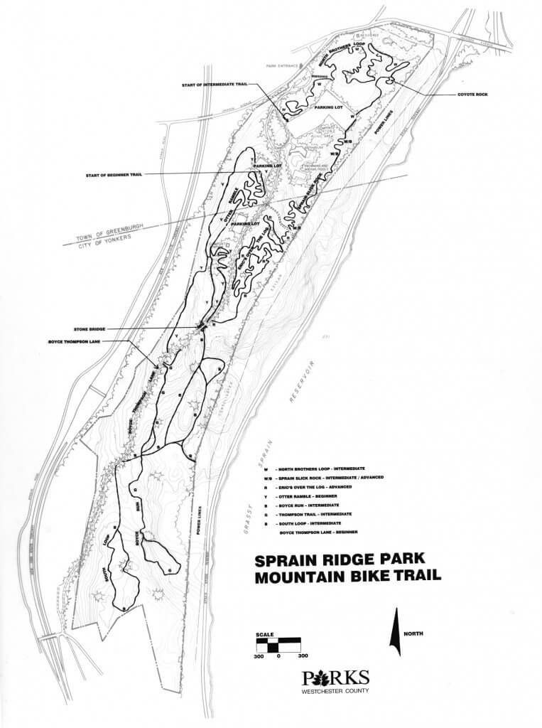
Start off with a warm-up climb out of the lot at trail marker two. Take the pink trail to the intersection with the Blue Loop. Ride up and around to the entrance to Disneyland at marker 6. Continue up the Blue Trail to the Updraft intersection at marker 26. Ride up both sections of Updraft to the near-summit at the White Trail intersection at marker 29. From here, you have a couple options depending on how long you have to ride.
For those in a hurry, continue straight onto the unmarked trail across from the summit of updraft (you’ll end up near the end of the orange trail, where you’ll make a right to get to marker 14 on the Blue Loop). This is a great, semi-technical off-camber descent and really makes you feel like you’re not in Westchester anymore. It cuts off a good chunk of the backside of Graham, but it’s fun and fast. At the intersection with the orange trail, you can also make a left and climb up until you reach the unmarked intersection with the also unmarked extension of the Green/Meadow trail. This adds a nice bit of trail to your ride and brings you back to the meadow area. If you made the choice to take a left at the top of Updraft, headed back to the Blue Loop and made a right to head down the Blue Loop Descent, this little bit of unmarked Green Trail extension is a nice detour.
For those looking for a bit more technical descent, head to the top of the Blue Loop Descent (marker 9). Rather than heading down the Blue Loop, make a left onto the Red Trail. This is definitely a “for experts only” option. At the bottom of this downhill-esque run, make a right and you’ll meet up with the bottom of the Blue Loop descent (marker 12). From here either take the Green Trail extension mentioned above, or head left on the Green Trail through the meadow area. If you take the meadow route, you’ll end up back on the Blue Loop. Take a right and continue back to the intersection with the Orange Trail at marker 14.
Now you’re in the home-stretch. Continue around the park on the Blue Loop. After you cross the open-area and end up at the Pit (marker 17), climb up the Blue Loop doubletrack and bang a left onto the Pink Trail. I prefer making a right (marker 18), descending and bearing left (marker 19) and heading straight/right (marker 21) into the easy Pink Trail loops for a cool-down. From here, just hop over the bridges on the Blue Loop spur and you’re back in the lot.